
Category
Report Builder
Product Version
7.3
Improvement of Dutch Maps
Not Planned
The Dutch standard maps don't have a lot of detail, and the aspect of the Netherlands is wrong. If you compare this to the Netherlands, you see what I mean.
I talked to Glen last week, he told me to add a ticket to load new charts.
 I like this idea
Hi Jurgen,
I hope all is well,
I will have this ticket converted to an Idea, we will then review this to see what can be done. Fingers crossed we can have some movement on this over the coming weeks. Before convert this I would love to get your feedback. I look forward to your reply.
Regards,
Mark
Hi Jurgen,
I hope all is well,
I will have this ticket converted to an Idea, we will then review this to see what can be done. Fingers crossed we can have some movement on this over the coming weeks. Before convert this I would love to get your feedback. I look forward to your reply.
Regards,
Mark
Hi Mark,
It's fine to register it as an idea. But I hope one that can be converted in an idea that will be realized. Is this a general problem or only with the Dutch maps? We are working a lot with geo-analysis at the moment. In Google maps we mis things like heatmaps and spots. Would it be possible to add those to Google Maps? The maps of Google (or OpenStreetmaps) are fine to work with.
Regards,
Jurgen
Hi Jurgen,
Thanks for getting back to me. I will strongly push this towards my Team Leader to see what can be actioned. I can see the need for this with how you have described and therefore would love to get this implemented for you. Let me go ahead and convert this to an idea and reach out to my Team Leader.
Regards,
Mark
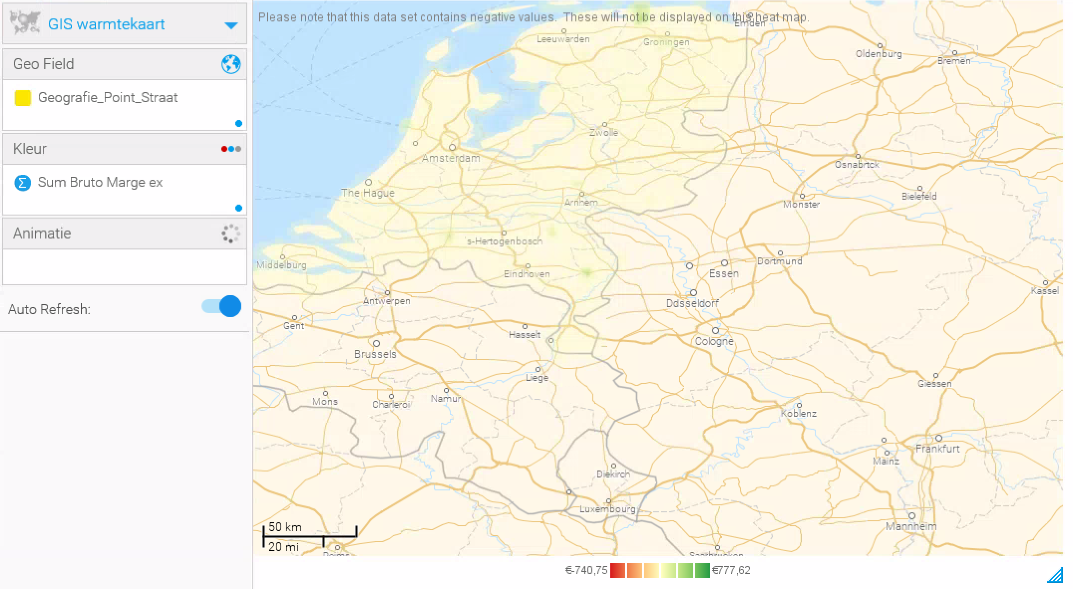
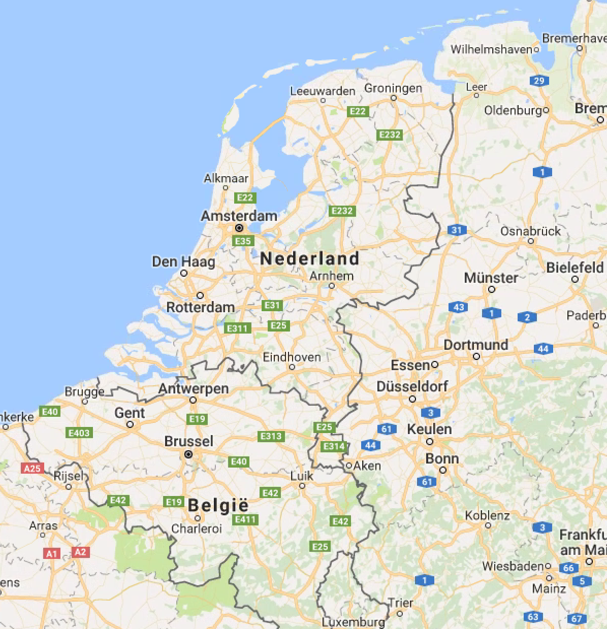
This idea is questioning if we can have a much better detailed dutch map (maps in general) as our current setup on this does not reflect a true detailed-likeness when comparing to Google Maps.
Yellowfin
Google Maps
This idea is questioning if we can have a much better detailed dutch map (maps in general) as our current setup on this does not reflect a true detailed-likeness when comparing to Google Maps.
Yellowfin
Google Maps
Hi Jurgen,
I hope all is well, I have since discussed this further with my team leader and we looked at the following areas:
If you have this data (available from GeoPack) you can have this displayed on normal Google Maps.
I can provide more information with regards to our maps available at YF.
Link 1 | Link 2 | Link 3
Let me know you views on this. I look forward to your reply.
Regards,
Mark
I'm wondering if there are any future plans to 'update' the maps as mentioned in this ticket.
Google maps causes limitations, so we have to move to ESRI maps for enhanced reporting on maps.
Regards,
Jurgen
I'm wondering if there are any future plans to 'update' the maps as mentioned in this ticket.
Google maps causes limitations, so we have to move to ESRI maps for enhanced reporting on maps.
Regards,
Jurgen
Hi Jurgen,
I hope all is well,
In my previous reply I stated the following:
***
I have since discussed this further with my team leader and we looked at the following areas:
If you have this data (available from GeoPack) you can have this displayed on normal Google Maps.
I can provide more information with regards to our maps available at YF.
Link 1 | Link 2 | Link 3
***
Let me know you views on this. I look forward to your reply.
Regards,
Mark
Hi Jurgen,
Apologies for the delay in responding... I have discussed this with my team and we have come to the decision that this be submitted to our Dev team to see what options we have. From what we can see you require that the map be more defined with how it is scaled.
Looking at the Google Maps it appears to have a flat map effect whereas the YF Map appears to show a more rounded effect. We can track this with the JIRA ID of YFN-10430
With this have you considered WMS?
Let me know your opinions of this. I look forward to your reply.
Regards,
Mark
Replies have been locked on this page!